Life decisions and Geography: Buying a house, part I
I recently bought a house with my partner, and it was quite an adventure. We always thought we would rent a house first, but when we started looking, we were hit with the hard truth: that it was way more expensive to rent than buying our own.
We lived in different cities, so the first decision was in which to live. Since family plays a vital role in our lives, we focused our search where they are: Sintra and Montijo.

Sintra and Montijo Municipalities
The price for a 3-bedroom house were similar in both municipalities, so that wouldn’t be the decisive factor… What was it? Peace of mind. Sintra is a lovely place, but… has a lot of people… All the time! It’s a very touristic place, with almost magical atmosphere. During the Pandemic, in Sintra, whenever I left home, I had to wear a mask and respect social distancing. In Montijo, however, I was able to take walks more freely because there weren't so many people on the streets. That and… Pena Palace was already taken :)

Pena Palace in Sintra - Photo by Oleg Shakurov
So, we ended up choosing Montijo as our future city. And then, let the games begin: Where would we want to live? How would we choose the perfect location for our home sweet home?
As any big decision, we had to make a list of important things we needed to have nearby. We had to think of everything we need right now and what we could possibly need in the future. As I see, at different stages of life we will have different needs/priorities, for example:
Young adults – Family, Leisure places, Friends, Restaurants.
Adults – Supermarkets, Parks, Schools, Pharmacies.
Senior – Family, Healthcare, Supermarkets, Pharmacies.
Regardless the stage, accessibility plays a major role in choosing the location. We don’t need to be at walking distance of all those places, but we need to have a way to reach them “quickly”. Since my family is within a 40-min drive, accessibility to the bridge to Lisbon was a big plus.
So, I decided to make a suitability model for Montijo, according to the priorities defined above. I used OpenStreetMap's data as source of POI’s. Montijo has 14 supermarkets, 11 pharmacies, 3 schools, 5 healthcare facilities, 8 leisure centers, 148 restaurants and 18 parks. With this data, I proceeded to normalize it and assign weights:
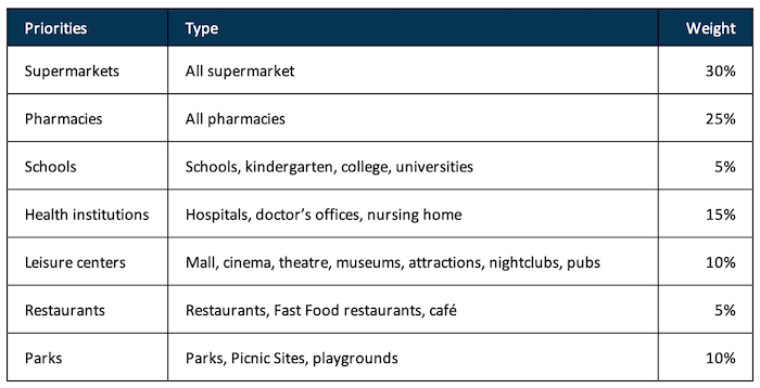
Table 1: Weights to the Suitability Model
With the weights assigned, I was able to calculate and represent the results on a map. It became clear where are the areas that could interest us the most are and we were able to quickly narrow down our search.

Suitability Model results
We looked on a lot of real estate websites and we were actively looking every time we went for a walk. With no luck, we contacted some people and ended up visiting a few houses, none of them good enough for what we were looking for.
Now, I’m not saying that our phones are listening to us… but… There were some buildings that seemed perfect to me. They were within walking distance of everything we needed (in an area of medium high suitability), and close enough to the bridge. Absolutely everything we needed. And what happened, you ask? I was scrolling on Instagram and an ad of a real estate agency showed up with one of those buildings.
Consequently, we went to see the house and it was love at first sight (or should I say visit). With the house chosen, another adventure began, but that is for another day…